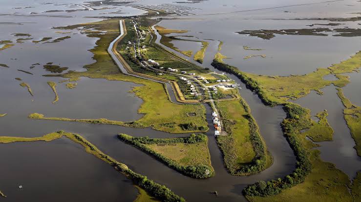
Louisiana loses a football field of land every 90 to 100 minutes. Not during storms. Not as a result of floods or disasters. Just on any given day, at a rate so steady you could almost set a watch to it. I want to try to make that real for you, because a statistic that big has a way of staying abstract.
What That Actually Looks Like
A standard American football field is 360 feet long and 160 feet wide. That is 57,600 square feet, just under an acre and a half of land. Louisiana is losing that much every hour and a half, continuously, every day.
Since the 1930s, the state has lost more than 2,000 square miles. To put that in terms that might land differently: that is larger than the state of Delaware. An entire state worth of land, gone in less than a century.
This is not happening evenly across the coast. Some areas are eroding far faster than others. The Terrebonne Basin, the Atchafalaya Delta, the area south and east of New Orleans around Plaquemines Parish: these regions are losing land at rates that are hard to look at directly. Communities that were surrounded by marsh a generation ago are now surrounded by open water.
Why It Is Happening
The land loss has multiple causes, and they compound each other in ways that make the situation harder to reverse than any single factor would suggest.
The Mississippi River used to deposit millions of tons of sediment across the Louisiana delta every year. That sediment built the land. When the Army Corps of Engineers built the levee system to control flooding, they also stopped the river from doing that work. The sediment now flows straight to the deep Gulf and sinks. The delta is no longer being replenished.
At the same time, the oil and gas industry dredged more than 10,000 miles of canals through the coastal marshes over the course of the 20th century. Those canals let saltwater intrude into freshwater wetlands, killing the marsh grasses whose root systems literally hold the land together. When the vegetation dies, the soil erodes. When the soil erodes, open water replaces marsh.
Add subsidence: the land is sinking. Extraction of oil, gas, and groundwater from underground causes compaction. Parts of New Orleans are sinking at more than an inch a year. Meanwhile, sea level in the Gulf of Mexico is rising faster than the global average, driven by climate change. The land is going down. The water is going up. The math is not good.
Then come the hurricanes. Katrina stripped away approximately 100 square miles of wetlands in a single storm in 2005. Ida did significant damage in 2021. A healthy marsh absorbs storm surge. A degraded marsh does not. Each storm that hits weakened wetlands does damage that would have been impossible on a healthy coast.
How to See It for Yourself
The data on Louisiana land loss is publicly available and genuinely striking to look at. The USGS National Assessment of Shoreline Change is one of the best resources: it maps historical shoreline positions and calculates erosion rates at the meter-per-year level. The Louisiana Coastal Protection and Restoration Authority (CPRA) also maintains a land change dataset through their Master Plan Data and Analysis Portal.
For a visual experience, Google Earth is one of the most accessible tools. Search for Leeville, Louisiana, or Isle de Jean Charles, then use the historical imagery slider to move back through the decades. Watch the land disappear. It is one of the most eye-opening things I have done on a computer.
Or try ShoreSafe, the web application I built with Dylan Carey. Enter a ZIP code anywhere in coastal Louisiana and it returns a machine-learning-based prediction of erosion risk for that location, along with a probability estimate and a projected timeline of land loss. It is free and it works in your browser.
Why This Matters Beyond the Numbers
The land being lost is not empty. It is the habitat of millions of migratory birds that fly the Mississippi Flyway. It is the nursery for the shrimp, crabs, and fish that support one of the most important seafood industries in the country. It is the buffer that absorbs storm surge before it reaches New Orleans.
And it is home. There are people whose families have lived on this coast for generations. Cajun fishers. Houma tribal members. Vietnamese shrimpers. Their cultures, their livelihoods, their ways of understanding the world are rooted in a landscape that is vanishing.
The football field statistic is real. But the full weight of what is being lost does not fit in a number.